
.png&w=3840&q=75)
.png&w=3840&q=75)
Evidence foundations
Satellite-derived surface heat evidence, urban data layers, exposure context and social vulnerability inputs prepared for spatial comparison.
Climate Risk and Resilience Solutions
THERMALIS helps cities turn satellite and urban data into clear maps, priorities and planning outputs for heat-risk resilience.
Product overview
THERMALIS is a decision-support system designed to make climate-related heat pressure more visible and manageable for cities. It combines satellite imagery, urban data layers and social vulnerability indicators to show where priorities emerge, why they matter and what types of interventions may be considered.
How it works
THERMALIS does more than place data layers on a map. It combines surface heat pressure, exposure, social vulnerability and adaptive capacity to produce priority outputs city teams can use.
.png&w=3840&q=75)
Automation architecture
The product is designed as a repeatable workflow: collect evidence, normalize it, prioritize places, explain the drivers and package outputs for institutional use.
Satellite-derived surface heat evidence, urban data layers, exposure context and social vulnerability inputs prepared for spatial comparison.
Quality checks, scoring logic, component comparisons, sensitivity views and explainable local profiles.
Executive-ready maps, priority lists, profile cards, web visuals and report content for planning and coordination.
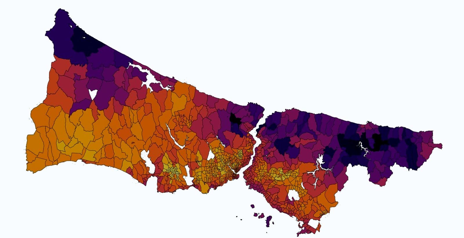
Real metropolitan pilot
The Istanbul pilot shows how THERMALIS operates with real metropolitan-scale data. The system combines surface heat pressure, exposure, social vulnerability and adaptive capacity to identify priority intervention areas at district and neighborhood scale.
A metropolitan view of the pilot geography and the evidence package prepared for spatial prioritization.
.png&w=3840&q=75)
Output Explorer
THERMALIS turns technical analysis into maps, priority lists, profile cards, scenario sensitivity summaries and report-ready outputs for city teams.
Citywide and local map views that show where planning attention should start.
.png&w=3840&q=75)
Compact profile cards that translate component drivers into a briefing-ready local view.
.png&w=3840&q=75)
A transparent way to compare proxy planning assumptions through priority-score point sensitivity.

Map packages, lists and concise decision material prepared for coordination and review.
For cities and civic climate organizations
THERMALIS helps municipal departments and European civic climate organizations move from scattered spatial data to a shared, explainable planning basis.
Locate priority areas across districts and neighborhoods before detailed field review and project design.
Translate technical evidence into a clear portfolio of places, drivers and next-step planning questions.
Bring social vulnerability context into spatial prioritization without turning it into a simplistic label.
Use comparable outputs to frame pilots, grant narratives and cross-city learning agendas.
Municipalities, metropolitan agencies, climate adaptation teams, resilience offices, universities, European NGOs and civic innovation programs.
Contact
Share a city question, a pilot geography or an institutional planning need. THERMALIS can structure the evidence workflow around that decision context.